The database tables contains geodata of the Federal Republic of Germany with geo referenced towns, municipalities, town quarters and other administrative units, postal codes, telephone preselections, nature areas, landscapes, climatic zones and official topographical cartographies. The data contain coordinates for navigation and geo-coding, proximity searches and distance computations and are prepered for the spatial mapping of environmental information. Quite often it is necessary to reference an address field e.g. like town or municipality name, postal code or telephone preselection, to corresponding geographical data and coordinates - a Geo Reference. The geo reference can be used e.g. to direct a customer to the closest store locations of a retail store chain by doing a proximity search. Another possibility it to determine distances between the different objects of the database tables with the included geo references. With the elevation data from a Digital Elevation Model the ground level height of each place can be determined. Often the knowledge is necessary about affiliations and relationships between data derived from different hierarchies. So it can be determined to which federal state, governmental area or governmental county a town, a postal code or a telephone preselection is associated. It is possible to assign a variety of natural and scenic information to each town or municipality. The snow and wind load zones and solar irradiation are available as local climatic data. In conjunction with the ground level heights they can be used to calculate static loads for the planning of building constuctions and to calculate solar installations. Databases: 11.500 Towns and Municipalities, 108.000 Town Quarters, 31.000 Postal Codes, 19.500 Telephone Preselections, all with geo references, 400 Administrative Countys, Administrative Districts, Federal States of Germany, Landscapes, Nature Area Classification, Snow and Wind Load Zones, Solardata, Cartographies.
Databáze obsahuje geodata Spolkové republiky Nemecko geo odkazy mesty, okresy, administrativní jednotky PSC, telefonní kódy oblasti prírodních oblastí, krajiny, klimatu a topografických map série. Data obsahují souradnice pro navigaci a geokódování, pro obvod vyhledávání a výpocty vzdálenosti a pro územní mapování informací o životním prostredí jsou vhodné. Informace jsou uloženy v ruzných databázových tabulek, které mohou být propojeny klíc. Casto je nutné rešit jeden prvek, napr. místní jméno, poštovní smerovací císlo nebo telefonní císlo oblasti, místní reference - vytvorit - reference geo. Referencní geo lze využít napr. pro volání zákazníka v blízkosti hledání jeho nejbližší pobocky retezce obchodu. Vzdálenosti mezi místy, nebo poštovní oblasti, lze urcit pomocí tabulek obsažených v databázi souradnic. Díky nadmorské výšce dat z digitálního modelu terénu, je možné výšky terénu každé místo urcit. Casto znalost vztahu a orientace je nutné v ruzných hierarchií. Napríklad urcit, které federální stát, správní obvod místo, poštovní smerovací císlo nebo telefonní predcíslí patrí. Je možné priradit každé místo ruzných prírodních krajin a malebné informace. Snehem a vetrem zóny jsou k dispozici jako site-specific klimatických údaju. Mohou být použity pro výpocet statického zatížení stavebních prací v souvislosti se zvýšením terénu. Databáze: 11.500 mest, obcí 108.000, PSC 31000, 19500 kódy telefonního obvodu, 400 okresu a kraju, okresu, státu, jednotky krajinné oblasti, snehu a zón zatížení vetrem, oficiální topografické mapy.
Databasen indeholder geodata af Forbundsrepublikken Tyskland med geo refereres byer, distrikter, administrative enheder, postnumre, telefon områdenumre, naturområder, landskaber, klima og topografiske kort serie. De data, der indeholder koordinater til navigation og geo-kodning, for perimeter søgninger og distance beregninger og for geografisk kortlægning af miljøoplysninger er egnede. Oplysningerne gemmes i forskellige databasetabeller, der kan kobles sammen af ??nøgle. Ofte er det nødvendigt at behandle en funktion, fx stednavn, postnummer eller telefon område kode, et lokale reference - skabe - en geografisk reference. Den geografiske reference kan bruges fx til at kalde en kunde i en nærhed ransage hans nærmeste grene af en kæde af butikker. Afstande mellem steder eller postområder kan bestemmes ved hjælp af tabellerne i databasen koordinater. Med højdedata fra en digital højdemodel, kan terrænet højden af ??hvert sted skal bestemmes. Ofte er viden om relationer og tilhørsforhold er påkrævet inden for forskellige hierarkier. For eksempel, bestemt være at der forbundsstat, administrative distrikt et sted, et postnummer eller telefon områdenummeret tilhører. Det er muligt at tildele hvert site en bred vifte af naturlandskaber og naturskønne oplysninger. Sne og vindlast zoner er tilgængelige som stedsspecifikke klimatiske data. De kan bruges til at beregne statiske belastninger for anlægsarbejderne i forbindelse med terrænet stigninger. Databaser: 11.500 byer og byer, 108.000 landsbyer, 31.000 postnumre, 19.500 telefon områdenumre, 400 distrikter og amter, amter, stater, Naturområde enheder, sne og vindlast zoner, officielle topografiske kort.
De database bevat geodata van de Bondsrepubliek Duitsland met geo verwezen steden, wijken, administratieve eenheden, postcodes, telefoon netnummers, natuurgebieden, landschappen, klimaten en de topografische kaart serie. De gegevens bevatten coördinaten voor navigatie en geo-codering, voor de perimeter zoeken en afstand berekeningen en voor de ruimtelijke in kaart brengen van milieu-informatie zijn geschikt. De informatie wordt opgeslagen in verschillende database-tabellen die bij elkaar kunnen worden gekoppeld met een sleutel. Vaak is het nodig om een ??functie te pakken, bijvoorbeeld de plaatsnaam, postcode of telefoon netnummer, een lokale referentie - maken - een geografische referentie. De geografische referentie kan bijvoorbeeld gebruikt worden voor het oproepen van een klant in een omgeving zoek zijn naaste takken van een keten van winkels. Afstanden tussen plaatsen of post gebieden kunnen worden bepaald met behulp van de tabellen in de database coördinaten. Met de hoogte van gegevens uit een digitaal hoogtemodel, kan het terrein hoogte van elke plaats worden bepaald. Vaak is de kennis van de relaties en voorkeuren is vereist binnen de verschillende hiërarchieën. Bijvoorbeeld worden bepaald welke federale staat, administratief district een plaats, een postcode of telefoon netnummer behoort. Het is mogelijk om elke site toe te wijzen een verscheidenheid aan natuurlijke landschappen en landschappelijke informatie. De sneeuw-en windbelasting zones zijn beschikbaar als locatie-specifieke klimatologische gegevens. Ze kunnen worden gebruikt om de statische belastingen voor de bouw werkzaamheden in verband met het terrein verhogingen te berekenen. Databases: 11.500 steden en dorpen, 108.000 dorpen, 31.000 postcodes, 19.500 telefonische netnummers, 400 districten en provincies, provincies, staten, landschappen, Natuur oppervlakte-eenheden, sneeuw-en windbelasting zones, de officiële topografische kaarten.
La base de données contient des géodonnées de la République fédérale d'Allemagne avec géo référencé des villes, des districts, unités administratives, des codes postaux, indicatifs téléphoniques, des espaces naturels, des paysages, des climats et des séries de cartes topographiques. Les données contiennent des coordonnées de navigation et de géo-codage, pour les perquisitions périphériques et des calculs de distance et de la cartographie spatiale de l'information environnementale sont adaptés. Les informations sont stockées dans des tables de bases de données différentes qui peuvent être reliés entre eux par clés. Souvent, il est nécessaire d'aborder une caractéristique, par exemple, le nom de lieu, code postal ou le code régional de téléphone, une référence locale - créer - une référence géo. La référence géo peut être utilisé par exemple pour appeler un client dans une proximité fouiller son plus proche succursales d'une chaîne de magasins. Les distances entre les lieux ou zones postal peut être déterminé en utilisant les tables contenues dans la base de données de coordonnées. Avec les données d'altitude à partir d'un modèle numérique d'élévation, la hauteur du terrain de chaque lieu peut être déterminé. Souvent, la connaissance des relations et des affiliations est requis dans les différentes hiérarchies. Par exemple, être déterminée à laquelle l'État fédéral, district administratif un lieu, un code postal ou le code régional de téléphone appartient. Il est possible d'attribuer à chaque site une variété de paysages naturels et d'information touristique. La neige et les zones de charge de vent sont disponibles comme données spécifiques au site climatiques. Ils peuvent être utilisés pour calculer les charges statiques pour les travaux de construction en liaison avec les élévations du terrain. Bases de données: 11 500 villes et villages, 108 000 villages, 31 000 codes postaux, 19500 indicatifs téléphoniques ...
Die Datenbank enthält Geodaten der Bundesrepublik Deutschland mit georeferenzierten Orten, Ortsteilen, administrativen Einheiten, Postleitzahlen, Telefon-Vorwahlen, Naturräumen, Landschaften, Klimazonen und topgraphischen Kartenwerken. Die Daten enthalten Koordinaten für die Navigation und Geokodierung, für Umkreissuchen und Entfernungsberechnungen und sind für die räumliche Zuordnung ökologischer Informationen geeignet. Die Daten sind in verschiedenen Datenbanktabellen abgelegt, die über Schlüssel miteinander verbunden werden können. Oft ist es notwendig zu einem Adressmerkmal, z.B. dem Ortsnamen, der Postleitzahl oder der Telefonvorwahl, einen örtlichen Bezug - eine Georeferenz - herzustellen. Die Georeferenz kann z.B. dafür verwendet werden, einem Kunden in einer Umkreissuche die ihm nächstgelegenen Filialen einer Geschäftskette zu nennen. Entfernungen zwischen Orten oder postalischen Gebieten können mit den in den Datenbanktabellen enthaltenen Koordinaten ermittelt werden. Mit den Höhenangaben aus einem digitalen Höhenmodell kann die Geländehöhe jedes Ortes festgestellt werden. Oft ist auch die Kenntnis von Zusammenhängen und Zugehörigkeiten innerhalb verschiedener Hierarchien erforderlich, z.B. zu welchem Bundesland, Regierungsbezirk, Kreis ein Ort, eine Postleitzahl oder eine Telefonvorwahl gehört. Es ist möglich jedem Ort naturräumliche, landschaftliche und klimatische Informationen zuzuordnen. Die Schnee- und Windlastzonen und die Solareinstrahlung stehen als ortsbezogene klimatische Daten zur Verfügung, Sie können in Verbindung mit den Geländehöhen dazu verwendet werden statische Lasten für die Bauausführung sowie Solaranlagen zu berechnen. Datenbanken: 11500 Städte und Gemeinden, 108000 Ortsteile, 31000 Postleitzahlen, 19500 telefonische Ortsnetzvorwahlen, alle mit Georeferenzen, 400 Kreise und Landkreise, Regierungsbezirke, Bundesländer, Landschaften, Naturräumliche Einheiten, Schnee- und Windlastzonen, Solardaten, Amtliche topographische Kartenwerke.
Il database contiene dati geografici della Repubblica Federale di Germania con le città geo referenziate, distretti, unità amministrative, codici di avviamento postale, prefissi telefonici, aree naturali, i paesaggi, climi e serie di carte topografiche. I dati contengono le coordinate per la navigazione e geo-codifica, per le ricerche perimetro e calcoli di distanza e per la mappatura spaziale delle informazioni ambientali sono adatte. Le informazioni sono memorizzate in tabelle di database diversi che possono essere collegate tra loro da chiave. Spesso è necessario affrontare una caratteristica, ad esempio, il nome della località, codice postale o prefisso telefonico, un riferimento locale - creare - un riferimento geo. Il riferimento geo può essere utilizzato ad esempio per chiamare un cliente in una ricerca di prossimità il suo più vicino rami di una catena di negozi. Le distanze tra luoghi o zone postale può essere determinata utilizzando le tabelle contenute nel database di coordinate. Con i dati di elevazione da un modello digitale di elevazione, l'altezza del terreno di ogni luogo può essere determinato. Spesso la conoscenza delle relazioni e le affiliazioni è necessario all'interno delle gerarchie diverse. Per esempio, essere determinato a cui stato federale, distretto amministrativo un luogo, un codice postale o prefisso telefonico appartiene. E 'possibile assegnare ad ogni sito una varietà di paesaggi naturali e le informazioni scenico. La neve e le zone di carico del vento sono disponibili dati climatici site-specific. Possono essere utilizzati per calcolare carichi statici per i lavori di costruzione in relazione elevazioni del terreno. Basi di dati: 11.500 città e paesi, 108.000 villaggi, 31.000 codici di avviamento postale, prefissi telefonici 19500, 400 distretti e contee, contee, stati, unità di Area Natura, neve e le zone di carico del vento, ufficiali mappe topografiche.
Baza danych zawiera geodanych Republiki Federalnej Niemiec z geo odwoluje miast, dzielnic, jednostek administracyjnych, kodów pocztowych, numerów kierunkowych telefonicznych, terenów zielonych, krajobrazy, klimat i topograficzne serii map. Dane zawieraja wspólrzedne dla nawigacji i geokodowanie, do wyszukiwania obwodzie i obliczenia odleglosci i przestrzennego mapowania informacji o srodowisku sa odpowiednie. Informacje te sa przechowywane w róznych tabelach bazy danych, które moga byc polaczone przez klucz. Czesto jest to niezbedne do podjecia jedna cecha, np. nazwy miejscowosci, kod pocztowy lub numer kierunkowy telefonu, lokalne odwolanie - tworzenie - odniesienie geograficzne. Odniesienia geograficzne moga byc uzywane np. do wywolywania klienta w odleglosci przeszukac jego najblizszej galezi sieci sklepów. Odleglosci miedzy miejscami lub obszarów pocztowych mozna okreslic za pomoca tabel zawartych w bazie danych wspólrzednych. Z danych elewacji z cyfrowego modelu terenu, teren wysokosc kazdego miejsca mozna okreslic. Czesto znajomosc relacji i powiazan jest wymagane w rózne hierarchie. Na przyklad, okresla, do których panstwo federalne, powiat miejsce, kod pocztowy lub numer kierunkowy telefonu nalezy. Mozliwe jest przypisanie kazdej z nich rózne naturalne krajobrazy i malownicze informacji. Sniegu i stref obciazenia wiatrem sa dostepne jako site-specific dane klimatyczne. Moga one byc wykorzystane do obliczenia statyczne obciazenie dla prac budowlanych w zwiazku z terenu elewacji. Bazy danych: 11.500 miast i miejscowosci, 108 tysiecy wiosek, 31000 kodów pocztowych, 19.500 kierunkowy telefonu, 400 powiatów i okregów, powiatów, stwierdza, jednostki Obszar Natura, snieg i stref obciazenia wiatrem, oficjalnych map topograficznych.
O banco de dados contém dados geográficos da República Federal da Alemanha com cidades geo referenciados, distritos, unidades administrativas, códigos postais, os códigos de área do telefone, áreas naturais, paisagens, climas e séries mapa topográfico. Os dados contêm coordenadas para navegação e geo-codificação, para pesquisas de perímetro e cálculos de distância e para o mapeamento espacial de informações ambientais são adequadas. As informações são armazenadas em tabelas de banco de dados diversos que podem ser ligados entre si por chave. Muitas vezes é necessário abordar um recurso, por exemplo, o nome do local, CEP ou código de área do telefone, uma referência local - criar - uma referência geo. A referência geo pode ser usada por exemplo para chamar um cliente em uma proximidade mais próxima a sua busca ramos de uma cadeia de lojas. Distâncias entre os lugares ou áreas postal pode ser determinado usando as tabelas contidas no banco de dados de coordenadas. Com os dados de elevação a partir de um modelo de elevação digital, a altura do terreno de cada local pode ser determinado. Muitas vezes o conhecimento das relações e filiações é necessária dentro de hierarquias diferentes. Por exemplo, estar determinado a que distrito federal, estadual, administrativa um lugar, um código postal ou código de área do telefone pertence. É possível atribuir cada local, uma variedade de paisagens naturais e informações cênica. A neve e zonas de carga de vento estão disponíveis como site-specific dados climáticos. Elas podem ser usadas para calcular cargas estáticas para as obras em conexão com as elevações de terreno. Bancos de dados: 11.500 cidades e vilas, aldeias 108.000, 31.000 códigos postais, 19.500 códigos de área do telefone, 400 distritos e condados, municípios, estados unidades de área de natureza, neve e zonas de carga de vento, oficial mapas topográficos.
La base de datos contiene datos geográficos de la República Federal de Alemania con las ciudades geo referenciada, los distritos, unidades administrativas, códigos postales, códigos telefónicos zona, las áreas naturales, paisajes, climas y series de mapas topográficos. Los datos contienen las coordenadas para la navegación y geo-codificación, para las búsquedas perimetrales y cálculos de distancia y de la cartografía espacial de la información ambiental son adecuados. La información se almacena en las tablas de bases de datos diferentes que pueden ser unidos entre sí por su clave. A menudo es necesario para hacer frente a una característica, por ejemplo, el nombre del lugar, el código postal o el código de área telefónica, una referencia local - crear - una referencia geográfica. La referencia geográfica se puede utilizar por ejemplo para llamar a un cliente en una búsqueda de proximidad a su más cercano ramas de una cadena de tiendas. Las distancias entre los lugares o zonas postales se puede determinar usando las tablas contenidas en las coordenadas de base de datos. Con los datos de elevación de un modelo digital de elevación, la altura del terreno de cada lugar se puede determinar. A menudo, el conocimiento de las relaciones y las afiliaciones se requiere dentro de las jerarquías diferentes. Por ejemplo, determinar en qué estado distrito federal, administrativo un lugar, un código postal o el código de área telefónica pertenece. Es posible asignar a cada sitio una gran variedad de paisajes naturales y escénicos de información. La nieve y las zonas de carga de viento están disponibles como datos específicos del sitio climáticas. Pueden ser utilizados para calcular las cargas estáticas para los trabajos de construcción en relación con las elevaciones del terreno. Bases de datos: 11.500 ciudades y pueblos, 108.000 aldeas, 31.000 códigos postales, 19.500 códigos de área telefónica, 400 distritos y condados, condados, estados, unidades de Área Natural ...
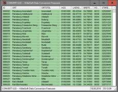
All tables updated to the data status of 1 January 2021. Table LASTEN supplemented with snow loads >3 and >3a. DHDN coordinates in degree notation and Google Plus codes added. Formerly municipial free areas added and landscapes completed. Snow and wind loads and solar radiation from all locations.
22.02.2016
20.00
Major Update
All databases actualized on level 1st January 2016. Databases ORTGEM, ORTREF, ORTTLGEM, ORTTLREF with unique record ID for simple updating. Reactivated License Plates entered in database KREIS. 8100 new town quarters added in databases ORTTLGEM and ORTTLREF.
Разрешения на распространение: Hereby Killet GeoSoftware Ing.-GbR permits to distribute their software 'Geodata Germany' exclusive as demo version on data media and in the online media up to revocation. We guarantee to possess all rights on the software. We exempt the legal distributor of our software from requirements third. With the revocation of the permission all projects in work with our software may be led to the end.
The license models described here require only a unique payment. No additional payments are raised as a function of the number of installations or on the service life of the license. The service life is unlimited. The data of the presented country data base tables can be used as data volumes of computer programs and Internet sites (applications) and can be passed in the context of the application to customers. The data are licensed for different types of use: A single data base table license entitles the license holder to use the data base table with a single software application licensed to the data base tables license holder. The software application that comes with the data base table can be passed to any number of customers or it can be installed as a single application on the Internet Server of the license holder or the server of the license holder's Internet service provider. A general data base table license entitles the license holder to use the data base table with any number of software applications licensed to the data base tables license holder. Software applications that come with the data base table can be passed to any number of customers and can be installed on a single or multiple Internet servers of the license holder or license holder's Internet service provider.


 Галерея


 Geodata Germany 25.02