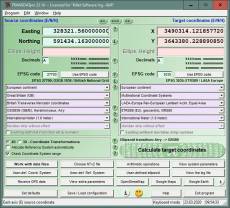
TRANSDAT geosoftware executes coordinate transformations and geodetic datum shifts between many coordinate and reference systems of America, Australasia, Europe, Germany special and world-wide, with high precision and high speed: 1.The current and historical coordinate and reference systems of all countries of the European Union (EU) including the eastern extensions and the systems of non-EU countries. 2. The INSPIRE supported European ETRS89 systems. 3. The US and Canadian State Plane Coordinate Systems (SPCS) on NAD27 and NAD83 and other coordinate systems of the North American continent. 4. The coordinate and reference systems of the Australasian continent. 5. Many coordinate and reference systems of the countries of other continents. 6. World-wide NTv2 grid file supported coordinate transformations. 7. All global coordinate and reference systems. 8. The German coordinate and reference systems of the old and new federal states, the 40 Prussian Soldner Land Registers, the German Lagestatus, and exact reference systems of the German federal states. You will find a complete list of the coordinate and reference systems supported by the program on the web or after downloading the free test version of the program. The NTv2 standard with national grid files is world-wide full supported. Apart from the given world-wide and state-specific systems, your own personal coordinate systems and geodetic reference systems can be defined with Helmert (Bursa / Wolf, ISO 19111) or Molodensky parameters. Calculations can be performed with coordinates entered directly, loaded from files in various formats (Text, CSV, SDF, dBase, KML, ArcShape, ArcGenerate), or passed by batch processing. ArcShape files can be viewed with the internal Shape Viewer. A programmable GPS interface makes it possible to read coordinates from a low-cost GPS antenna. The program can be run on a network, in which case clients are installed automatically. The program has a multilingual interface.
TRANSDAT geosoftware voert coördinaat transformaties en geodetisch datum verschuivingen tussen veel coördinaat en referentie systemen van Amerika, Australië, Europa, Duitsland speciale en wereldwijd, met hoge precisie en hoge snelheid: 1. de huidige en historische coördineren en verwijzen naar systemen van alle landen van de Europese Unie (EU), met inbegrip van de Oost-extensies en de systemen van niet-EU-landen. 2. De INSPIRE gesteunde Europese ETRS89 systemen. 3. De Amerikaanse en Canadese staat vliegtuig Coordinate Systems (SPC) op NAD27 en NAD83 en andere coördinatensystemen van het Noord Amerikaanse continent. 4. De coördinaat en referentie systemen van de Australasian continent. 5. Veel coördinaat en referentie systemen van de landen van andere continenten. 6. World-wide NTv2 raster bestand ondersteund coördinaat transformaties. 7. Alle globale coördinaat en referentie-systemen. 8. De Duitse coördinaat en referentie systemen van de oude en de nieuwe federale staten, de 40 Pruisische Soldner Land Registers, de Duitse Lagestatus en exacte referentiesystemen van de Duitse deelstaten. U vindt een complete lijst van de coördinaat en referentie-systemen ondersteund door het programma op het web of na het downloaden van de gratis testversie van het programma. De standaard NTv2 met national grid bestanden is wereldwijd volledig ondersteund. Afgezien van de gegeven world-wide en staatspecifieke systemen, uw eigen persoonlijke coördinaat systemen en geodetisch referentiesystemen met Helmert kunnen worden gedefinieerd (Bursa / Wolf, ISO 19111) of Molodensky parameters. Berekeningen kunnen worden uitgevoerd met coördinaten rechtstreeks ingevoerd, geladen vanuit bestanden in verschillende formaten (tekst, CSV, SDF, dBase, KML, ArcShape, ArcGenerate) of doorgegeven door batch-verwerking. ArcShape bestanden kunnen worden bekeken met de interne vorm Viewer. Een programmeerbare GPS-interface maakt het mogelijk om te lezen van de coördinaten van een low-cost GPS antenne.
TRANSDAT géo-software exécute des transformations de coordonnées et des déplacements entre le système géodésique de nombreuses coordonnées et systèmes de référence en Amérique, en Australie, en Europe, en Allemagne et dans le monde, avec une grande précision et à grande vitesse: L 'INSPIRE pris en charge les systèmes ETRS89 Européenne à l'égard de la dérive des continents. Les systèmes courants et beaucoup de systèmes anciens de coordonnées et d'informations de tous les états de l'Union Européenne (EU) incluant les pays de l'Est intégrés de 2004 à 2007 et les systèmes des pays européens non-membres de la communauté. Les systèmes européens ETRS089 supportés par INSPIRE prenant en compte la dérive des continents. Les États-Unis d'Amérique et le Canada State Plane Systems (SPCS) sur le NAD27 et NAD83 et d'autres systèmes de coordonnées et de références du continent Nord-Américain. Les systèmes de coordonnées et de références du continent d'Asie Australe. 5.Beaucoup de systèmes de coordonnées et de références de pays d'autres continents. Transformations de coordonnées mondiales supportée par fichier de grille NTv2. Systèmes de coordonnées et de références universels. Les systèmes d'informations et de coordonnées des anciens et nouveaux Länder au niveau fédéral, les 40 systèmes Soldner prussiens, le "Lagestatus" allemand et des systèmes des régions individuelles. Vous trouverez une liste complète des systèmes de coordonnées et de références pris en charge par le programme sur Internet ou après avoir téléchargé la version d'essai gratuite du programme. TRANSDAT fonctionne selon la directive d'INSPIRE et les instructions de conversions prescrites par celle-ci ETRS89 avec données de la grille NTv2, p. ex. Gauss-Kruger / DHDN à UTM / ETRS89 avec BeTA2007. La norme NTv2 avec des fichiers de réseaux nationaux fonctionnelle dans le monde entier. Outre les systèmes installés, vos propres systèmes de coordonnées et de systèmes de références géodésiques peuvent être définis ...
TRANSDAT berechnet für Deutschland, Europa und weltweit professionelle Koordinatentransformationen und Datumswechsel zwischen internationalen und landesspezifischen Koordinatensystemen in hoher Qualität und mit großer Geschwindigkeit: 1. Die Deutschen Koordinaten- und Bezugssysteme der alten und neuen Bundesländer, die 40 preußischen Soldner-Systeme, die Deutschen Lagestatus und genaue Bezugssysteme der einzelnen Bundesländer. 2. Die aktuellen und viele historische Koordinaten- und Bezugssysteme aller Staaten der Europäischen Union (EU) einschließlich der Osterweiterungen von 2004 und 2007 und die Systeme der Europäischen Nicht-EU-Länder. 3. Die von INSPIRE unterstützten Europaweiten ETRS89-Systeme unter Berücksichtigung der Kontinentaldrift. 4. Die Amerikanischen und Kanadischen State Plane Koordinatensysteme (SPCS) in den Bezugssystemen NAD27 und NAD83 und andere Systeme des Nordamerikanischen Kontinents. 5. Die Koordinatensysteme und Bezugssysteme des Australasiatischen Kontinents. 6. Weltweit die mit NTv2-Gitterdateien unterstützten Koordinatentransformationen. 7. Viele Koordinaten- und Bezugssysteme der Länder anderer Kontinente. 8. Alle weltumspannenden Koordinaten- und Bezugssysteme. Eine vollständige Liste der vom Programm unterstützten Koordinaten- und Bezugssysteme steht nach dem Download der Testversion zur Verfügung. Neben den vielen vor eingestellten Systemen können beliebige Koordinatensysteme und geodätische Bezugssysteme nach Helmert (Bursa / Wolf, ISO 19111) oder Molodenski selbst definiert werden. Das Programm ist für die Direkteingabe, für die Bearbeitung von Koordinatendateien (Text, CSV, SDF, dBase, KML, ArcShape und ArcGenerate) und für die Stapelverarbeitung (Batch) eingerichtet. ArcShape-Dateien können im programminternen Shape-Betrachter angesehen werden. Eine programmierbare GPS-Schnittstelle ermöglicht das Einlesen von Koordinaten aus einer preiswerten GPS-Antenne ins Notebook. Das Programm hat eine mehrsprachige Benutzeroberfläche.
TRANSDAT geosoftware esegue trasformazioni coordinate e riferimento geodetico si sposta tra molti sistemi di coordinate e di riferimento dell'America, Australasia, Europa, Germania, speciale e di tutto il mondo, con alta precisione e alta velocità: 1. l'attuale e storico coordinare e sistemi di tutti i paesi dell'Unione europea (UE) comprese le estensioni orientali e i sistemi dei paesi extra-UE di riferimento. 2. La INSPIRE ETRS89 europeo sistemi supportati. 3. Gli Stati Uniti e la canadese stato aereo sistemi di Coordinate (SPCS) su NAD27 e NAD83 e altri sistemi di coordinate del continente nord-americano. 4. I sistemi di coordinate e riferimento del continente Australasian. 5. Molti sistemi coordinate e il riferimento dei paesi di altri continenti. 6. In tutto il mondo NTv2 griglia file supportato trasformazioni coordinate. 7. Tutto globali sistemi di coordinate e di riferimento. 8. I tedesco sistemi coordinate e riferimento dei vecchi e nuovi Stati federali, il 40 prussiano Soldner terra registra, la tedesca Lagestatus e sistemi di riferimento esatto degli Stati federali tedeschi. Troverete una lista completa dei sistemi di coordinate e riferimento supportato dal programma sul web o dopo aver scaricato la versione di prova gratuita del programma. Lo standard di NTv2 con i file di rete elettrica nazionale è completamente supportato in tutto il mondo. A prescindere dai sistemi dato a livello mondiale e specifiche per lo stato, i propri sistemi di coordinate personali e i sistemi di riferimento geodetici possono essere definiti con Helmert (Bursa / Wolf, ISO 19111) o i parametri di Molodensky. I calcoli possono essere eseguiti con coordinate entrato direttamente, caricati da file in vari formati (testo, CSV, SDF, dBase, KML, ArcShape, ArcGenerate) o passati per l'elaborazione in batch. ArcShape i file possono essere visualizzati con il visualizzatore interno di forma. Un'interfaccia programmabile GPS permette di leggere le coordinate da un'antenna GPS a basso...
TRANSDAT cálcula para Europa, EUA, Austrália, Alemanha e no mundo inteiro, transformações profissionais de coordenadas e data entre sistemas internacionais e coordenadas específicas nacionais em alta qualidade e alta velocidade: As sistemas de coordenadas e de referência correntes e muitos históricos de todos os países da União Europeia (UE),incluindo as extensões leste a partir de 2004 e 2007 e os sistemas dos países europeus não pertencentes à UE. Os sistemas ETRS89 à escala europeia suportados de INSPIRE tendo em conta da deriva continental. Os sistemas de coordinadas (SPC) State Plane de EUA e Canadá nos sistemas de referência NAD27 NAD83 e outros sistemas do continente norte-americano. Os sistemas de coordenadas e sistemas de referência do continente austral asiático. Muitos sistemas de coordenadas e de referências de países de outros continentes. Os transformaçoes de coordenadas apoiados com arquivo grid NTv2 mundiais. Todos sistemas de coordenadas e de referência usados globalmente. As sistemas de coordenadas e de referência alemães dos estados antigos e novos, as 40 sistemas da Prússia Soldner, o status de posição alemã (Lagestatus) e os sistemas de referência exata de cada um dos estados. Uma lista completa de os programas apoiadando as sistemas de coordenadas e de referência e disponível depois de baixar a versão livre de test da Internet. TRANSDAT apoia todos conversões ETRS89 prescrito pela directiva INSPIRE com dados grid NTv2, por exemplo, Gauss-Krüger / DHDN de UTM / ETRS89 com BeTA2007. A norma Ntv2 com arquivos grid nacionais e apoiado no mundo todo. Além dos muitos sistemas pré-definidos também poden ser definidos sistemas arbitrários de coordenadas e sistemas de referência geodésicos de Helmert (Bursa / Wolf, ISO19111) ou de Molodenski. O programa é projetado para a entrada direta de coordenadas para o processamento de arquivos de coordenadas (texto, dBase, CSV, SDF, KLM, ArcGenerate, ArcShape) e o processamento em lote ...
TRANSDAT geosoftware realiza transformaciones de coordenadas y datum geodésico cambios entre muchos sistemas coordenadas y sistemas referencia de América, Oceanía, Europa, Alemania especiales y en todo el mundo, a la alta precisión y alta velocidad: 1. El actual y muchos históricos sistemas coordenadas y sistemas de referencia de todos los países de la Unión Europea (UE), incluidas las extensiones del este entre 2004 y 2007 y los sistemas de los países Europeos no comunitarios. 2. El INSPIRE apoyado los sistemas europeos ETRS89 con respecto a la deriva continental. 3. El EE.UU. de América y Canadá sistemas coordenadas State Plane (SPC) en NAD27 y NAD83 y otros sistemas de coordenadas y de referencia del continente de América Norte. 4. El sistemas coordenadas y sistemas referencia del continente Australiano. 5. Muchos sistemas coordenadas y sistemas referencia de los países de otros continentes. 6. A nivel mundial archivo la rejilla NTv2 apoyada transformaciones de coordenadas. 7. All universal sistemas coordenadas y sistemas referencia. 8. El Alemán sistemas coordenadas y sistemas de referencia de los estados federados antiguos y nuevos, el 40 de Prusia Soldner Registros de la Propiedad, "Lagestatus" de Alemánia y los sistemas de referencia exacta de los estados federales Alemanes. Usted encontrará una lista completa de las sistemas coordenadas y sistemas de referencia apoyado por el programa en Internet o después de descargar la versión de prueba gratuita del programa. TRANSDAT soporta todos por la directiva INSPIRE prescrito conversiones ETRS89 con los datos de la red NTv2, p. ej. Gauss-Kruger / DHDN a UTM / ETRS89 con BeTA2007. La norma NTv2 con los archivos de la rejilla nacional en todo el mundo completo apoyo. Aparte de los sistemas dados en todo el mundo y específicos de cada estado, su propio sistemas de coordenadas personales y sistemas geodésicos de referencia puede ser definido con Helmert (Bursa / Wolf, ISO 19111) parámetros o Molodenski. ...
Program is faster and more stable using a new development system. NTv2 reference systems for Belgium and Portugal added. New language interfaces for Italian, Bosnian, Croatian and Serbian. NTv2 reference systems TOKYO, JGD2000 and JGD2011 of Japan added. EPSG codes of Austria, Spain, Portugal.
Разрешения на распространение: Hereby Killet GeoSoftware Ing.-GbR permits to distribute their software TRANSDATpro exclusive as shareware version on data media and in the online media up to revocation. We guarantee to possess all rights on the software. We exempt the legal distributor of our software from requirements third. With the revocation of the permission all projects in work with our software may be led to the end.
A single program license entitles the license holder to use the program on a single computer in the license holders place of work. A network program license entitles the license holder to use the program on a single network of the license holders principal branch/subsidiary office. A general program license entitles the license holder to use the program on all computers and networks of the license holders branch/subsidiary office.


 Галерея


 TRANSDATpro 24.12