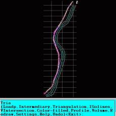
An add-on for AUTOCAD or BricsCAD, which makes the triangulation of a set of POINT entities, the intersection curves (isolines) between a set of 3DFACE entities and a set of equidistance plans, horizontally or vertically and the volume and center of gravity of a set of bodies or between surfaces composed of 3DFACE entities. You can also load and draw a file of points having the format: Number X Y Z Code. The drawing of the XYZ files is made with POINT, 3DPOLY, SPLINE or BLOCK entities, according to a modifiable library of codes. The triangulation is performed on a convex hull of a set of points. You can triangulate million points! The isolines can be interpolated and their colors are according to a drawn legend. The isolines having Z a multiple of a value will be drawn thickened. You can define a clipping parallelepiped for isolines. You can also make the projection over a triangulation of a 2D POLYLINE and generate cross sections and a longitudinal profile corresponding at projection. The POLYLINE may contain arcs. Color-filled contour maps can be also generated.
In addition, you can draw a DWG file in Google Earth, by generating a 2D or 3D KML file type. The DWG file can be in any projected coordinate system and from any part of the globe. It is also possible to determine the flatness of the surfaces and you can import and export LandXML file type!
Une application d'AUTOCAD ou BricsCAD, qui fait la triangulation d'un ensemble de points, les courbes d'intersection (les isolignes) entre un ensemble d'entités 3DFACE et un ensemble de plans equidistances, horizontalement ou verticalement et le volum d'un ensemble d'entités 3DFACE. Vous pouvez également charger et dessiner un fichier de points ayant le format : Numéro X Y Z Code. Le dessin des fichiers XYZ est faite avec POINT, 3DPOLY, SPLINE ou entités BLOCK, selon une bibliothèque de codes modifiables. La triangulation est effectué sur une enveloppe convexe d'un ensemble de points. Vous pouvez trianguler millions de points! Les isolines peuvent être interpolés et leurs couleurs sont selon une légende. Les isolines ayant Z un multiple d'une valeur, seront dessinées épaissie. Vous pouvez définir un parallélépipède de coupure pour des isolines. Vous pouvez également effectuer la projection sur une triangulation d'un POLYLINE 2D et génèrer des coupes et un profil longitudinal correspondant à la projection. Le POLYLINE peut-être contenir des arcs. Des cartes de contours colorés peuvent également être générés.
En outre, vous pouvez dessiner un fichier DWG dans Google Earth, en générant un fichier de type KML 2D ou 3D. Le fichier DWG peut être en aucun système de coordonnées projetées et de ne importe quel partie du globe. Vous pouvez déterminer la planéité des surfaces et importer et exporter des fichiers LandXML!
Eine AUTOCAD oder BricsCAD Anwendung für Topografie: Triangulation, Isolinien, das Zeichnen von XYZ Punktdateien mit Codes, Volumen, Längsprofile und Querschnitte für eine gegebene Code oder für die Projektion einer POLYLINE. Die Punktedatei hat das Format 'Nummer X Y Z Code' und wird mit POINT, 3DPOLY, SPLINE oder BLOCK Einheiten gezeichnet, gemäß einer änderbaren Codes-Bibliothek. Es können Millionen von Punkten trianguliert werden! Die Isolinien können gemäß einer Farblegende interpoliert und gezeichnet werden. Man kann auch mit Farben gefüllte Umrisskarten generieren.
Darüber hinaus können Sie eine DWG-Datei in Google Earth zu ziehen, durch Erzeugen einer KML-Datei-Typ 2D oder 3D. Die DWG-Datei kann in jedem Koordinatensystem und von jedem Teil der Welt zu sein. Sie können die Ebenheit der Oberflächen bestimmen und Sie können den Dateityp LandXML importieren und exportieren!
Un'applicazione di AUTOCAD o BricsCAD che rende la triangolazione di un insieme di entità POINT, le curve di intersezione (isolinee) tra un insieme di entità 3DFACE e una serie di piani di equidistanza, orizzontale o verticale e il volume e il centro di gravità di una insieme di organi o tra superfici composte da entità 3DFACE. È anche possibile caricare e disegnare un file di punti che hanno il formato: numero di codice XYZ. Il disegno dei file XYZ è fatto con entità POINT, 3DPOLI, una spline o Blocca, secondo una libreria modificabile di codici. La triangolazione è eseguita su un convesso di un insieme di punti. È possibile triangolare milioni di punti! Le isolinee possono essere interpolati e loro colori sono secondo una leggenda disegnato. Le isolinee aventi Z un multiplo di un valore verrà disegnata ispessite. È possibile definire un ritaglio di parallelepipedo per isolinee. È inoltre possibile effettuare la proiezione su una triangolazione di una polilinea 2D e generare sezioni trasversali e profilo longitudinale corrispondente alla proiezione. La polilinea può contenere archi. Mappe di contorno di colore pieno possono anche essere generati.
Inoltre, è possibile disegnare un file DWG in Google Earth, generando un tipo di file KML 2D o 3D. Il file DWG può essere in alcun progettato sistema di coordinate e da qualsiasi parte del globo. È possibile determinare la planarità delle superfici ed è possibile importare ed esportare il tipo di file LandXML!
Um pedido de AutoCAD ou BricsCAD, o que torna a triangulação de um conjunto de ponto, as curvas de intersecção (isolinhas) entre um conjunto de 3DFACE e um conjunto de planos equidistance, horizontalmente ou verticalmente, e o volume e o centro de gravidade de um conjunto de organismos ou entre superfícies compostas de entidades 3DFACE. Você também pode carregar e desenhar um arquivo de pontos com o formato: Número Código XYZ. O desenho dos arquivos XYZ é feito com o ponto, 3DPOLY, SPLINE ou bloquear as entidades, de acordo com uma biblioteca de códigos modificável. A triangulação é realizada num casco convexo de um conjunto de pontos. Você pode triangular milhão de pontos! As isolinhas podem ser interpolados e suas cores são de acordo com uma lenda desenhado. As isolinhas com Z um múltiplo de um valor serão sorteados engrossar. Você pode definir um recorte de paralelepípedo para isolinhas. Você também pode fazer a projeção sobre a triangulação de um polígono 2D e gerar seções transversais e um perfil longitudinal correspondente à projeção. O POLYLINE podem conter arcos. Mapas de contorno cheio de cor também pode ser gerada.
Além disso, você pode desenhar um ficheiro DWG no Google Earth, através da geração de um arquivo do tipo KML 2D ou 3D. O ficheiro DWG pode estar em qualquer sistema de coordenadas e a partir de qualquer parte do globo. Você pode determinar o nivelamento das superfícies e pode importar e exportar o tipo de arquivo LandXML!
Ключевые слова: Aplicatii AutoCAD, Topografie, Triangulatie, Creator KML, KML 3D, Izolinii, fisiere XYZ, Harti de contururi umplute cu culori, Sectiuni, Volume, Google Earth, planeitate suprafete, BricsCAD
O aplicatie AUTOCAD sau BricsCAD pentru topografie: triangulatie, izolinii, desenare de fisiere XYZ de puncte cu coduri, volume, profil longitudinal si sectiuni transversale pentru un cod dat sau pentru proiectia unui POLYLINE. Fisierul de puncte are formatul 'Numar X Y Z Cod' si se va desena cu entitati POINT, 3DPOLY, SPLINE sau BLOCK, conform unei biblioteci modificabile de coduri. Se pot triangula milioane de puncte! Izoliniile pot fi interpolate si desenate conform unei legende de culori. Se pot genera si harti de contururi umplute cu culori.
Se poate desena, de asemenea, un fisier DWG 2D sau 3D in Google Earth. Fisierul DWG poate fi in sistemul de proiectie STEREO 70 (Romania) sau in orice alt sistem! Se poate determina planeitatea suprafetelor si se pot importa si exporta fisiere de tip LandXML.
Una aplicación AUTOCAD o BricsCAD para topografía: triangulación, isolineas, dibujo de ficheros XYZ de puntos con códigos, volúmenes, perfil longitudinal y secciones transversales para un código dado o para la proyección de un POLYLINE. El POLYLINE puede contener arcos. El fichero de puntos tiene el formato 'Número X Y Z Código' y se dibujará con entidades POINT, 3DPOLY, SPLINE o BLOCK, de acuerdo con una biblioteca modificada de códigos. Se pueden triangular millones de puntos! Las isolineas pueden ser interpoladas y dibujadas conforme a una leyenda de colores. Puede definir un recorte paralelepípedo de isolíneas. Se pueden genera también mapas de contornos rellenos de colores.
Además, se puede dibujar un archivo DWG en Google Earth, mediante la generación de un archivo de tipo KML 2D o 3D. El archivo DWG puede estar en cualquier sistema de coordenadas y desde cualquier parte del mundo. ¡Puedes determinar la planitud de las superficies y puedes importar y exportar el tipo de archivo LandXML!
Разрешения на распространение: This SOFTWARE may be distributed freely on online services, bulletin boards, or other electronic media as long as the files are distributed only "AS IS" in this installation package. This SOFTWARE may not be distributed on CD-ROM, disk, or other physical media for a fee without the permission of the Author.
All copyrights of 'TRIANGULATION' software application are exclusively owned by the author - RCAD SOFTWARE SRL.
LICENSE AGREEMENT
TRIANGULATION is shareware software application with 30 days trial period.
This Limited Use Software License Agreement (the 'AGREEMENT') is a legal agreement between you ('LICENSEE'), the end-user, and RCAD SOFTWARE SRL author ('AUTHOR') for the use of the TRIANGULATION software product, and may include associated media, printed materials and any 'online' or electronic documentation ('SOFTWARE').
By using this SOFTWARE or storing this program on a computer hard drive (or other media), you are agreeing to be bound by the terms of this AGREEMENT.
If you do not agree to the terms of this AGREEMENT, you may not install or use the SOFTWARE and you must delete it from all storage media.
You may install this SOFTWARE to test and evaluate it for a period of 30 days, if it suits your needs and you wish to purchase it.
Following this test period of 30 days or less, if you wish to continue to use the SOFTWARE, you MUST register. If you don't register the SOFTWARE after the 30 days evaluation period, you must delete the SOFTWARE from all storage media.
Once registered, the user is granted a exclusive license to use the SOFTWARE on one computer, for any legal purpose, at a time. The registered SOFTWARE may not be rented or leased.
This SOFTWARE may be distributed freely on online services, bulletin boards, or other electronic media as long as the files are distributed only 'AS IS' in this installation package. This SOFTWARE may not be distributed on CD-ROM, disk, or other physical media for a fee without the permission of the Author.
The SOFTWARE may not be bundled or distributed with any other package without written permission of the author.
The SOFTWARE is protected by copyright laws and international copyright treaties, as well as other intellectual property laws and treaties. The SOFTWARE is licensed, not sold.
You may not alter this SOFTWARE in any way, including changing or removing any messages or windows. You may not decompile, reverse engineer, disassemble or otherwise reduce this SOFTWARE to a human perceivable form. You may not modify, rent or resell for profit this SOFTWARE, or create derivative works based upon this SOFTWARE.
You may not publicize or distribute any registration code algorithms, information, or registration codes used by this SOFTWARE without permission of the Author.
You agree not to enter any serial/registration number into the Software for which you have not purchased or use any means to circumvent the Software protection mechanism, you also agree if you are found to have done so that the license to use the Software has terminated and any action(s) to report unauthorized access, piracy and disable access to the Software is permitted.
TRIANGULATION software (including documentation and/or additional materials) is owned by RCAD SOFTWARE SRL.
This Agreement does not provide you the title or ownership of the SOFTWARE, but only a limited right of use.
GENERAL DISCLAIMER AND WARRANTY
'TRIANGULATION' software and accompanying written materials are provided 'AS IS' without warranty of any kind.
Further, the author does not warrant, guarantee, or take any representations regarding the use, or the results of use, of the software or written materials in terms of correctness, accuracy, reliability or otherwise. The entire risk as to the results and performance of the software is assumed by you.
Neither the author nor anyone else who has been involved in the creation, production or delivery of this product shall be liable for any direct, indirect, consequential or incidental damages (including damages for loss of business profits, business interruption, loss of business information and the like) arising out of the use or inability to use the product even if the author has been advised of the possibility of such damages.
By using TRIANGULATION software you acknowledge that you have read this limited warranty, understand it, and agree to be bound by its' terms and conditions.
If the above terms and conditions cannot be legally applied by you then you are NOT licensed to use this software and absolutely may not use it for any purpose. You must remove this software from your system.
BY INSTALLING OR USING THIS SOFTWARE YOU INDICATE YOUR ACCEPTANCE OF THIS AGREEMENT. IF YOU DO NOT ACCEPT OR AGREE WITH THESE TERMS, YOU MAY NOT INSTALL OR USE THIS SOFTWARE !


 Галерея


 TRIANGULATION for AutoCAD 2.3